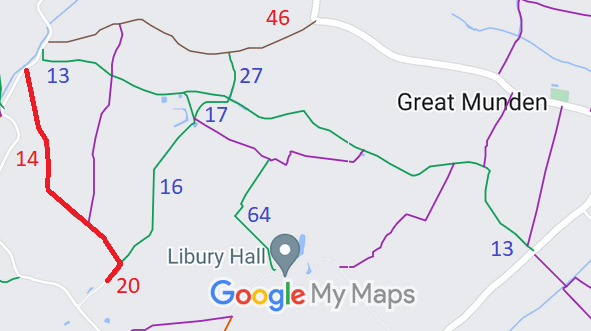
Annotated map reproduced courtesy of Googlemaps.
We need a volunteer to photograph this route for this year's Access and Riding Rights of Way Survey. It's easy - just take photographs (safely) when you use the path. Find out more!
| Paths Greenways Bridleways Tracks | ||
| PG: OBJECTS: PROMOTION: Great Munden 14 BOAT (Dark Lane) and Little Munden 20 BOAT | ||
Annotated map reproduced courtesy of Googlemaps. |
This page is still being prepared.
We need a volunteer to photograph this route for this year's Access and Riding Rights of Way Survey. It's easy - just take photographs (safely) when you use the path. Find out more! |
| Legal History 2 Feb 1953: The route was recorded as CRB (Carriage Road used as a Bridleway) on the original definitive map and statement. DM sheets DM2-03 (Herts 13 SE) and DM2-09 (Herts 21 NE). 31 Dec 1977: The route was shown as a bridleway on the special review draft map and statement. There must have been objections as the route reverted to RUPP. DM sheet SR-31 (TL32SW). 17 Aug 2000: HCC decision to make an order to show the route as a byway. File reference EC198. 9 Feb 2001: The Hertfordshire County Council (Great Munden 14) Modification Order 2001 recorded the status as byway open to all traffic. |
Definitive Statement (4 Dec 2015)
Path: [Great Munden] 14. Status: Byway Open to All Traffic. Definitive Map sheet: 31 Commences from county road S of Old Chalk Pit at TL 3341 2422 thence SE along Dark Lane past Baxter's Spring to junction with BR16 at parish boundary NE of Frog's Hall at TL 3380 2349. Width: Width varies from approx 5m to approx 18m as shown hatched between points P and Q on the plan forming part of the Hertfordshire County Council (Great Munden 14) Modification Order 2001. Limitations: None Path: [Little Munden] 20. Status: Byway Open to All Traffic.
Definitive Map sheet: 31 |
© 2024 Patchetts Green Bridleways Trust.
File reference: EC198.
