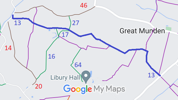
Annotated map reproduced courtesy of Googlemaps.
We need a volunteer to photograph this route for this year's Access and Riding Rights of Way Survey. It's easy - just take photographs (safely) when you use the path. Find out more!
| Paths Greenways Bridleways Tracks | ||
| PG: OBJECTS: PROMOTION: Great Munden 13 | ||
Annotated map reproduced courtesy of Googlemaps. |
This route starts from the Dane End to Nasty public road and continues generally norh-westwards or westwards to a junction with Great Munden 17 bridleway and Great Munden 27 bridleway, then generally westwards to a junction with Great Munden 16 bridleway and finally northwestards to the Rush Green to Haultwick public road.
We need a volunteer to photograph this route for this year's Access and Riding Rights of Way Survey. It's easy - just take photographs (safely) when you use the path. Find out more! |
| Legal History 2 Feb 1953: The route was recorded as CRB (Carriage Road used as a Bridleway) on the original definitive map and statement. DM sheets DM2-03 (Herts 13 SE) and DM2-09 (Herts 21 NE). 31 Dec 1977: The route was shown as a bridleway on the special review draft map and statement. There must have been objections as the route reverted to RUPP. DM sheets SR-31 (TL32SW) and SR-32 (TL32SE). 21 Dec 1998: Owner applies to delete Great Munden 13 RUPP from the definitive map. 11 Feb 2000: East Herts Footpath Society applies to upgrade Great Munden 13 RUPP to Byway. 17 Aug 2000: HCC decision to make an order to show the route as a byway. File reference EC198. 9 Feb 2001: The Hertfordshire County Council (Great Munden 13) Modification Order 2001 (confirmed 6 Apr 2004) recorded the status as bridleway. |
Definitive Statement (4 Dec 2015)
Path: [Great Munden] 13. Status: Bridleway. Definitive Map sheet: 31 and 32 Commences from a junction with the Dane End to Nasty road near the Plough public house at TL 3542 2358 thence north-west for approx 35m to a junction with FP8 at TL 3539 2360, continuing north-west, north and north-west for approx 370m to a junction with FP62 at TL 3521 2391, thence west for approx 125m to a junction with FP12 at TL 3509 2391, continuing south-west and north-west around the southern side of Bugby's Pightle and past Bugby's Farm for approx 380m to a junction with FP11 at TL 3475 2395, thence north-west and west for approx 620m to a junction with path 27 and bridleway 17 at TL 3420 2415, continuing west for approx 170m to a junction BR16 at TL 3403 2416, continuing west for approx 310m to a junction with FP15 at TL 3374 2422, continuing west for approx 280m to a point immediately to the east of the Rush Green to Haultwick road at TL 3347 2427 thence north for approx 45m to a junction with the same road at TL 3347 2432. Width: Width varies from approx 2m to approx 18m as shown hatched on the plan forming part of the Hertfordshire County Council (Great Munden 13) Modification Order 2001. Limitations: Gates at:- (A) Its junction with Dane End to Nasty road (TL 3542 2358) (D) Approximately 65 metres from its junction with the Dane End to Nasty road (TL 3537 2362) (E and/or F) The northern corner of plot 310 on the Ordnance Survey 2nd edition 1:2500 plan (TL 3527 2371) (G) Its entry to plot 290 from plot 307 on the Ordnance Survey 2nd edition 1:2500 plan (TL 3500 2390) (H) The eastern end of plot 292 on the Ordnance Survey 2nd edition 1:2500 plan (TL 3500 2389) (K) Bugby's Farm approximately 10 metres E of its junction with FP11 (TL 3476 2395) (L) A point W of Bugby's Farm, adjacent to the NE corner of plot 213 on the Ordnance Survey 2nd edition 1:2500 plan (TL 3471 2396) |
© 2025 Patchetts Green Bridleways Trust.
File reference: EC198, EC1069.
