Legal History
20 Jun 1953: The route was recorded as a bridleway on the original definitive map and statement. DM sheet DM3-35.
7 Mar 1967: The Hemel Hempstead Rural District Council (Martintops Farm, Flaunden) Public Path Diversion Order 1967 (confirmed 21 Jun 1967) diverted the route to the north side of Martin's Top Farm.
31 Dec 1977: The route was shown as a bridleway on the special review draft map and statement. DM sheet SR-74.
|
Definitive Statement (4 Dec 2015)
Path: [Flaunden] 6. Status: Bridleway.
Definitive Map sheet: 82
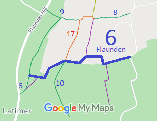
Commences at junction with BR5 at S end of Long Wood thence E past junction with FP7 thence NE skirting Gearys Plantation. Past the junction with BR10 and RB17 at TQ 0095 9961 and skirting N boundary of Baldwins Wood thence NE past N of Martins Top Farm thence SE to spinney thence E past FP2a to county road N of Oldfield Spring.
|