Paths Greenways Bridleways Tracks
 PG: OBJECTS: PROMOTION: Essendon 4
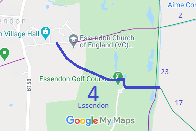
Map showing Essendon 4 bridleway
Annotated map reproduced courtesy of Googlemaps.
This route starts on School Lane and heads generally southeastwards to Bedwell Avenue (Bridleway 23) and Little Berkhamsted 17.

We need a volunteer to photograph this route for the 2021 Access and Riding Rights of Way Survey. It's easy - just take photographs (safely) when you use the path. Find out more!

BHS An examination of Quarter Sessions records at the Hertfordshire Archives showed that a bridleway had been diverted in Essendon that wasn't recorded on the definitive map. An application was made based on the court order. The County Council agreed with the application and an order was made in 2005. However, an Inspector decided that the order was defeective and so it was remade in 2008. One objection was made, but the Inspector decided that the order was correct and confirmed it.
This is a good example of legally proven paths that were simply missed in the definitive map process perhaps through lack of riders at the time of the survey. Such paths would be extinguished by the Countryside and Rights of Way Act 2000 had an application not been made in time.

Legal History
Quarter Sessions diversion order of bridleway, 1860. HALS reference QSR 82.
Essendon 4 was put forward as a bridleway at the draft map stage, but was recorded as a footpath following Objection 137.
20 Jun 1953: Essendon 4 was recorded as a footpath on the original (1953) definitive map and statement. DM sheet DM3-25.
31 Dec 1977: Essendon 4 was shown as a footpath on the special review (1977) draft map and statement. DM sheet SR-70.
1 Aug 1998: Application to upgrade to bridleway. HCC reference W+H/34.
The Hertfordshire County Council (Essendon 4) Modification Order 2005 proposed to upgrade Essendon 4 to BW and realign it. The order was found to be defective by an Inspector and so not confirmed. FPS/M1900/7/40.
The Hertfordshire County Council (Essendon 4) Modification Order 2008 was made to correct the 2005 order's deficiency. It was confirmed by an Inspector on 10 Mar 2010. FPS/M1900/7/53
Definitive Statement (4 Dec 2015)
Path: [Essendon] 4.  Status: Bridleway.  Definitive Map sheet: 70
Commences from a junction with School Lane (county road) west of school at TL 2765 0863 and continues SE for approx 380 metres passing to N and E of golf course clubhouse for approx 130 metres and then continuing generally E for 185 metres to a junction with Essendon BR 25 at TL 2824 0839 and continues generally E for approximately 10 metres to a junction with Essendon FP 22 and Little Berkhamsted 17 at TL 2825 0839.
Width: 5.1 m between TL 2765 0863 and TL 2769 0857. 4m between TL 2769 0857 and TL 2825 0839.
Limitations: None

© 2021 Patchetts Green Bridleways Trust. File reference: EC174.

Stats2