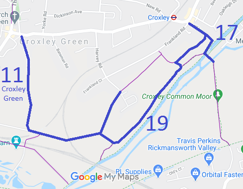
Annotated map reproduced courtesy of Googlemaps.
We need a volunteer to photograph these routes for this year's Access and Riding Rights of Way Survey. It's easy - just take photographs (safely) when you use the paths. Find out more!
| Paths Greenways Bridleways Tracks | ||
| PG: OBJECTS: PROMOTION: Croxley Green 11, 17 and 19 BW and Batchworth 17 BW | ||
Annotated map reproduced courtesy of Googlemaps. |
This network of bridleways was recorded in 2015.
We need a volunteer to photograph these routes for this year's Access and Riding Rights of Way Survey. It's easy - just take photographs (safely) when you use the paths. Find out more! |
| Legal History 20 Jun 1953: Croxley Green 11 was recorded as Rickmansworth 44 FP on the original definitive map and statement. DM sheet DM3-36 and DM3-42. 20 Jun 1953: Croxley Green 17 was recorded as Rickmansworth 50 FP on the original definitive map and statement. DM sheet DM3-36. 2010: The Hertfordshire County Council (Croxley Green 11, 17, 19, 20, 21 and 22) Modification Order 2010 confirmed with modifications 10 Feb 2015 added bridleway 19 and upgraded FP 11 and part of FP 17 to bridleway. 1 Apr 2017: Part of Croxley Green 17 is now in the newly-created Batchworth parish. The affected section is now known as Batchworth 17. |
Definitive Statement (4 Dec 2015)
Path: [Croxley Green] 11. Status: BW/FP. Definitive Map sheets: 83, 89 Commences as BR at junction with Watford Road (county road) and All Saints Lane at TQ 0700 9527, then S along All Saints Lane through Croxleyhall Wood for approx 570m to junction with Lavrock Lane at TQ 0706 9472, then E for approx 80m to junction with FP12 at TQ 0714 9470 and then E for approx 360m, over railway to junction with Croxley Green BR19 at TQ 0748 9470 and then NE for approx 290m to junction with Harvey Road (county road) at TQ 0761 9496. Continuing as FP NE past Long Valley Wood and FP22 to junction with Frankland Close between house No's. 51 and 53. Width: BR: Varies between 3m and 10m between TQ 0700 9527 and TQ 0761 9496, as shown shaded on parts 2, 3 and 4 of the Order Plan forming part of the Hertfordshire County Council (Croxley Green 11, 17, 19, 20, 21 and 22) Modification Order 2010. FP: 12' to 14' Limitations: None between TQ 0700 9527 All Saints Lane and TQ 0761 9496 Harvey Road.
Path: [Croxley Green] 17. Status: BW/FP.
Definitive Map sheets: 83, 89
Path: [Croxley Green] 19. Status: BW.
Definitive Map sheets: 83, 89 |
© 2023 Patchetts Green Bridleways Trust.
File reference: EC395.
