Paths Greenways Bridleways Tracks
 PG: OBJECTS: PROMOTION: Buckland Back Lane
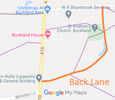
Map showing Back Lane, Buckland
Annotated map reproduced courtesy of Googlemaps.

This route runs from the A10 generally eastwards then northwards to the road from Buckland to Barkway.
BHS As part of the British Horse Society's work to record paths before Path Extinguishment Day, it was spotted that this route was part unrecorded and part recorded as a footpath, even though the historical evidence showed it was a public road. An application was made in 2016 to record the route as a restricted byway. We await determination.

Legal History
1844: Back Lane was shown on the Buckland tithe map as not subject to an apportionment.
1852: The northernmost 66 yards of Back Lane were set out as public carriage road No. 3 in the Buckland Inclosure Award.
2 Feb 1953: Part was recorded as Buckland 7 footpath on the original (1953) definitive map and statement. Remainder is unrecorded. DM sheet DM1-02.
10 Jan 2016: Application for Back Lane to be recorded as a restricted byway. HCC reference: EH/435.
Definitive Statement (4 Dec 2015)
Path: [Buckland] 7.  Status: Footpath.  Definitive Map sheet: 15
Commences at junction with Royston Road (A10) opposite Post Office thence NE past Moat to St Andrew's Churchyard, through churchyard across Back Lane thence NE across FP9 to junction with county road.

© 2024 Patchetts Green Bridleways Trust. File reference: EC925. HCC reference: EH/435/MOD.

Stats2