| Paths Greenways Bridleways Tracks | ||
| PG: OBJECTS: PROMOTION: Brickendon Liberty 28 | ||
| London Orbital Bridleroute: Anti-clockwise: Brickendon Liberty 14. Clockwise: Cock Lane to Brickendon Liberty 24. | H25 | |
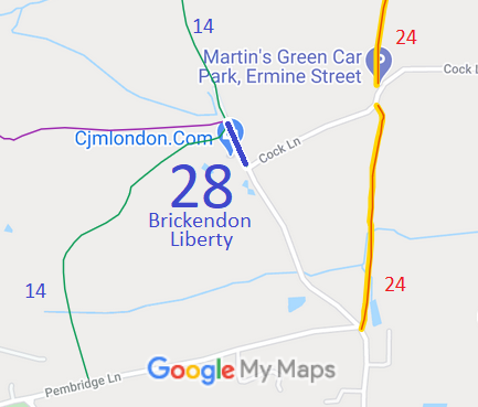
![]() Annotated map reproduced courtesy of Googlemaps. |
This short bridleway runs from Cock Lane (public road) to
Brickendon Liberty 14 bridleway.
We need a volunteer to photograph this route for this year's Access and Riding Rights of Way Survey. It's easy - just take photographs (safely) when you use the path. Find out more! |

|||
As part of the Patchetts Green Bridleways Trust's work to support the British Horse Society's London Orbital Bridleroute (H25) project, we collected user evidence for this short route that had been recorded as a bridleway.
The County Council agreed with the application and an order was made in 2007 and confirmed unopposed.
| ||||
| Legal History 6 Mar 2001: Application made to record route as a bridleway (user evidence). HCC reference EH/218. 16 Feb 2007: The Hertfordshire County Council (Brickendon Liberty 28) Modification Order 2007 (confirmed 18 May 2007) added this route to the definitive map and statement. |
Definitive Statement (4 Dec 2015)
Path: [Brickendon Liberty] 28. Status: Bridleway. Definitive Map sheet: 71 Commences from county road at TL 3441 0750 and continuing NW to the junction of BR14 at TL 3437 0759. Width: Varies from 2.8m to 3.2m between TL 3441 0750 and TL 3437 0759 as shown hatched on Order Plan 2 being part of the Hertfordshire County Council (Brickendon Liberty 28) Modification Order 2007 Limitations: None |
© 2022 Patchetts Green Bridleways Trust. File reference: EC190. HCC reference: EH/218.