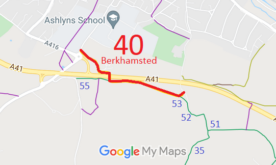
Annotated map reproduced courtesy of Googlemaps.
We need a volunteer to photograph this route for this year's Access and Riding Rights of Way Survey. It's easy - just take photographs (safely) when you use the path. Find out more!
| Paths Greenways Bridleways Tracks | ||
| PG: OBJECTS: PROMOTION: Berkhamsted 40 BOAT | ||
Annotated map reproduced courtesy of Googlemaps. |
This page is still being prepared.
We need a volunteer to photograph this route for this year's Access and Riding Rights of Way Survey. It's easy - just take photographs (safely) when you use the path. Find out more! |
| Legal History 20 Jun 1953: Northchurch 4 was recorded as CRB (Carriage Road used as a Bridleway) on the original definitive map and statement. DM sheet DM sheets DM3-19 (SP90NE) and DM3-20 (TL00NW). Northchurch 4 was renumbered Berkhamsted 40 when the parish boundary changed. 13 Oct 2000: The Hertfordshire County Council (A41 Berkhamsted and Kings Langley Bypasses) Legal Event Modification Order 2000 recorded the change to this route caused by the A41 works orders. |
Definitive Statement (4 Dec 2015)
Path: [Berkhamsted] 40. Status: Byway Open to All Traffic. Definitive Map sheet: 64 Commences at junction with Swing Gate Lane east of Ashlyn's Hall, thence S and NW through Sandpit Green (to SP 9933 0654) thence westwards on the south side of the A41 for approx. 300m to a junction with BR55 (at SP 9905 0655) thence northwards through the underpass (to SP 9905 0662) thence westwards for approx. 90m (to SP 9896 0664) thence northwestwards for approx. 250m to a junction with Chesham Road A416 (at SP 9879 0682) Limitations:None between SP 9903 0663 and SP 9933 0654. None between Chesham Road and SP 9896 0664. |
© 2024 Patchetts Green Bridleways Trust.