Paths Greenways Bridleways Tracks
 PG: OBJECTS: PROMOTION: Barkway 10 RB
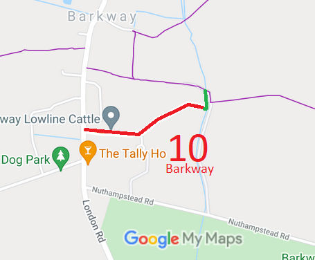
Map showing Barkway 10 restricted byway
Annotated map reproduced courtesy of Googlemaps.

A volunteer has photographed this route for this year's Access and Riding Rights of Way Survey, and the page will be updated shortly. Find out more!

BHS As part of the British Horse Society's work to record paths before Path Extinguishment Day, it was spotted that Barkway 10 did not reach the footpaths at its eastern end. The historical evidence showed a continuous route, so an application was made in 2021 to record the gap.
There have been several attempts to change the status or alignment of this path. In 2000, the North Hertfordshire District Council consulted on a proposed diversion and downgrade to footpath. In 2005, the County Council consulted on a similar application. Neither proposal reached order making stage. In 2013, the landowners again applied to divert the eastern end of the path, this time retaining the status as restricted byway. In 2015, agents for the landowners consulted on a diversion and downgrade to footpath status. In neither case did the proposals reach an order making stage.

Legal History
1 Nov 1953: The route was recorded as CRF (Carriage Road used as a Footpath) on the original definitive map and statement. DM sheet DM4-23.
31 Dec 1977: The route was shown as a footpath on the special review draft map and statement. DM sheet SR-8. There must have been objections because the change did not happen.
30 Mar 2005: HCC consulted on landowner application for diversion and downgrade to footpath. HCC reference NH/129/DIV. No order was made.
2 May 2006: Restricted Byway rights were confirmed or created on this path by virtue of ss 47 and 48 Countryside and Rights of Way Act 2000.
21 Jan 2013: Landowner applied to divert the western end of this route. HCC Reference NH/243/DIV. After consultation, no order was made.
17 Jun 2021: Application made to join up the western end of the mapped route with Barkway 12 as it was on the first definitive map. HCC reference NH/140.
Definitive Statement (4 Dec 2015)
Path: [Barkway] 10.  Status: Restricted Byway.  Definitive Map sheet: 8
Commences from Cambridge Road approx. 100 yards N of 'Tally Ho' P.H. E for approx. 215 yards then NE through farmyard at Rushingwells to parish boundary.

© 2022 Patchetts Green Bridleways Trust. File references: EC337, ED061.

Stats2
