Paths Greenways Bridleways Tracks
 PG: OBJECTS: PROMOTION: Aston 9 FP
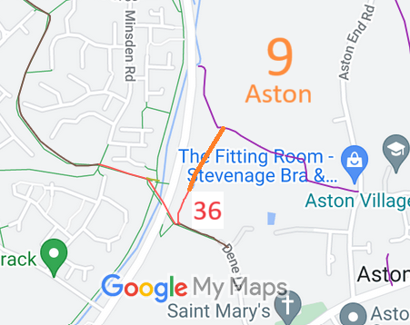
Map showing recorded Aston paths
Annotated map reproduced courtesy of Googlemaps.
This route starts from Aston 36 and Stevenage 111 restricted byway and continues generally northeastwards to a junction with Aston 8 footpath and Stevenage 106 footpath.

A volunteer has photographed this route for the 2024 Access and Riding Rights of Way Survey, and the page will be updated shortly. Find out more!

At the time of the 2024 Access Survey (30 Jun 24), there was a width restriction (prevented horses) at the southern end and it was signposted at the junction with Stevenage 111 restricted byway.

Legal History
1840: Aston 9 was shown on the Aston tithe map as not subject to an apportionment.
1857: Aston 9 was shown as a road on the inclosure map.
2 Feb 1953: Aston 9 was was recorded as a footpath on the original definitive map and statement. DM sheet DM2-08 (Herts 21 NW).
31 Dec 1977: The route was shown as a footpath on the special review draft map and statement. DM sheet SR-30 (TL22SE).
27 Jul 2024: Application for restricted byway status. HCC reference EH/544.

Application Process
Path Application Certificate Direction Inv Report Order Confirmed
EC1220B 27 Jul 2024 EH/544 9 Aug 24        

Definitive Statement (4 Dec 2015)
Path: [Aston] 9.  Recorded Status: Footpath.  Definitive Map sheet: 30
Commences at junction with county road NW of Aston Dene thence NE to junction with FP8
  Location Information
Postcode for SATNAV for anyone inspecting path: SG2 9PE (Bittern Close).

© 2024 Patchetts Green Bridleways Trust. File reference: EC1220B. DOBBIN reference: HER-0154 HCC reference: EH/544

Stats2