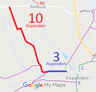
Annotated map reproduced courtesy of Googlemaps.
| Paths Greenways Bridleways Tracks | ||
| PG: OBJECTS: PROMOTION: Aspenden 3 BW and 10 RB | ||
Annotated map reproduced courtesy of Googlemaps. |
This route starts on Baldock Road as a restricted byway and heads generally southeastwards. The route changes to a bridleway on the definitive map and continues generally eastwards to Church Hill and Aspenden village. |
| Legal History 1841: Route parallel to Aspenden 3 was shown on the Aspenden tithe map as not subject to an apportionment. 1841: Aspenden 10 was shown on the Aspenden tithe map as not subject to an apportionment. 1 Oct 1869: Aspenden 3 was shown coloured as for other public roads on the Inclosure Map of Aspenden. 2 Feb 1953: Aspenden 3 was recorded as a footpath and Aspenden 10 was recorded as CRF (Carriage Road used as a Footpath) on the original definitive map and statement. DM sheet DM1-07. 31 Dec 1977: Aspenden 3 was shown as a bridleway on the special review draft map and statement. DM sheet SR-24. 31 Dec 1977: Aspenden 10 was shown as bridleway on the special review draft map and statement, but this change was not carried forwards. DM sheet SR-23. 2 May 2006: Restricted Byway rights were confirmed or created on Aspenden 10 by virtue of ss 47 and 48 Countryside and Rights of Way Act 2000. 11 Sep 2022: Overgrowth on Aspenden 3 eastern signage reported to HCC, reference 401002938784. 11 Sep 2022: Missing bridleway sign on Aspenden 3 western signage reported to HCC, reference 401002938786. |
Definitive Statement (4 Dec 2015)
Path: [Aspenden] 3. Status: Bridleway/Footpath. Definitive Map sheets: 23, 24 Commences at the bottom of Church Hill Aspenden thence SW by The Bourne and continuing to junction with path to Berkesdon Green thence N to Tannis Court. Path: [Aspenden] 10. Status: Restricted Byway.
Definitive Map sheets: 23, 24 |
© 2021 Patchetts Green Bridleways Trust.
File reference: EC804 (Aspenden 3).
