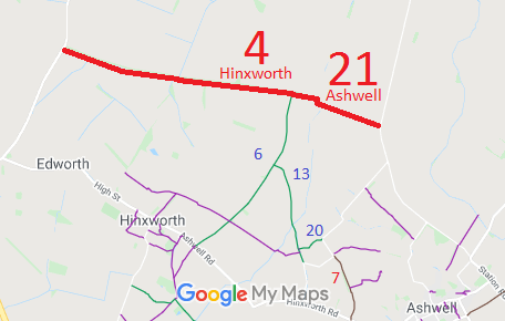
Annotated map reproduced courtesy of Googlemaps.
| Paths Greenways Bridleways Tracks | ||
| PG: OBJECTS: PROMOTION: Ashwell 21 BOAT, Hinxworth 4 BOAT and Edworth BOAT (Beds) | ||
Annotated map reproduced courtesy of Googlemaps. |
This route starts from Northfield Road and runs generally north eastwards to a junction with Hinxworth 6 bridleway, then continues generally east northeastwards to the Bedfordshire county boundary and on to the Millow to Edworth road. |
| Legal History 1 Nov 1953: Ashwell 21 and Hinxworth 4 were recorded as CRB (Carriage Road used as a Bridleway) on the original definitive map and statement. Sheet DM4-3 (Herts 3 NE). 31 Dec 1977: Ashwell 21 and Hinxworth 4 were shown as byway open to all traffic on the special review draft map and statement. DM sheets SR-1 (TL24SW) and SR-2 (TL24SE). |
Definitive Statement (4 Dec 2015)
Path: [Ashwell] 21. Status: Byway Open to All Traffic. Definitive Map sheet: 2 Commences from Northfield Road approx. 420 yards N of Common Lane thence NW to parish boundary at Barrowsford Bridge. Path: [Hinxworth] 4. Status: Byway Open to All Traffic.
Definitive Map sheet: 1, 2 |
© 2022 Patchetts Green Bridleways Trust.
