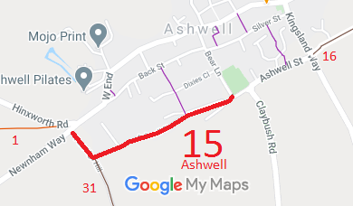
Annotated map reproduced courtesy of Googlemaps.
We need a volunteer to photograph this route for this year's Access and Riding Rights of Way Survey. It's easy - just take photographs (safely) when you use the path. Find out more!
| Paths Greenways Bridleways Tracks | ||||
| PG: OBJECTS: PROMOTION: Ashwell 15 BOAT | IWRR | |||
| Icknield Way (Hertfordshire East section): To the Ridgeway: Ashwell 31 byway. To the Peddars Way: Bear Lane, Ashwell Street and Ashwell 16 byway. | ||||
Annotated map reproduced courtesy of Googlemaps. |
This route starts on Newnham Way, heads generally southeastwards to a junction with Ashwell 31 restricted byway then turns generally eastwards to a junction with Bear Lane.
We need a volunteer to photograph this route for this year's Access and Riding Rights of Way Survey. It's easy - just take photographs (safely) when you use the path. Find out more! |
| Legal History 1841: Ashwell 15 was shown on the Ashwell tithe map as not subject to an apportionment. 1 Nov 1953: Recorded as CRB (Carriage Road used as a Bridleway) on the original definitive map and statement. It was reclassified to Byway Open to All Traffic. |
Definitive Statement (4 Dec 2015)
Path: [Ashwell] 15. Status: Byway Open to All Traffic. Definitive Map sheet: 6 Commences from county road by Partridge House thence SE for approx. 110 yards thence NE FP9 to southern end of Bear Lane. |
© 2022 Patchetts Green Bridleways Trust.