Legal History
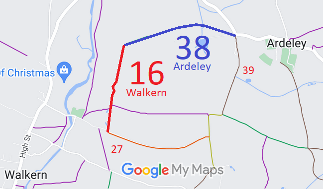
2 Feb 1953: Walkern 16 was recorded as CRF (Carriage Road used as a Footpath) on the original definitive statement. DM sheet DM1-37.
2 Feb 1953: Ardeley 38 was recorded as a footpath on the original definitive map and statement. DM sheet DM1-06 (H13NW).
31 Dec 1977: Walkern 16 and Ardeley 38 were shown as footpath on the special review draft map and statement. DM sheets SR-22 (TL22NE) and SR-23 (TL22NW).
30 Jul 2003: EHFS Application to upgrade Ardeley 38 FP to BW. HCC reference EH/288.
2005: Order made to upgrade to bridleway.
|
Definitive Statement (4 Dec 2015)
Path: [Ardeley] 38. Status: Bridleway.
Definitive Map sheet: 22 and 23
Commences at junction with county road north of Ardeley Bury Lodge (TL 3054 2721),
thence generally west past Ardeley Bury to join RUPP 16 at Walkern parish boundary (TL
2967 2711).
Width: 4 metres wide, except for a width of 2 metres from the junction with the county
road at point A for about 23 metres to Grid Reference TL 305 272 and for the
section over the bridge at Grid Reference TL 303 273 where the width is 2
metres.
Limitations: An old oak tree at Grid Reference: TL 302 273.
Statement refers to RUPP which should be RB.
Path: [Walkern] 16. Status: Restricted Byway.
Definitive Map sheets: 22
Commences from BR 38 at the parish boundary W of Ardeley Bury thence S to join
Restricted Byway 27 E of Church End.
|
 The East Herts Footpaths Society applied for this path to be recorded based on historical evidence, including a Quarter Sessions order.
The County Council agreed with the application and an order was made in 2005 and confirmed unopposed.
