Legal History
31 Dec 2000: The bridleway was dedicated by deed.
20 Jul 2006: The Hertfordshire County Council (Aldenham 81) Legal Event Modification Order 2006 added this route to the definitive map and statement
|
Definitive Statement (4 Dec 2015)
Path: [Aldenham] 81. Status: Bridleway.
Definitive Map sheets: 76, 77
Commences from a junction with Aldenham 20 at TL 1504 0116 thence westwards on
south of hedge to TL1449 0113 then continues on north side of hedge to rejoin Aldenham 20 at TL 1434 0120. This route was not dedicated as maintainable at public expense.
Width: 4.5m to 9.8m between TL 1449 0113 and TL 1434 0120;
4m between TL 1504 0116 and TL 1473 0114;
4m to 4.8m between TL 1473 0114 and TL 1449 0113
Limitations: Right of the landowner to permit trees, shrubs or hedges alongside the bridleway provided the useable width is not reduced to less than: 3.5m between TL 1504 0116 and TL 1473 0114 4m between TL 1473 0114 and TL 1434 0120
Right of the landowner to restrict width to not less than 1.52m at or within 10m
of the following points: TL 1504 0116 TL 1473 0114 TL 1449 0113.
|
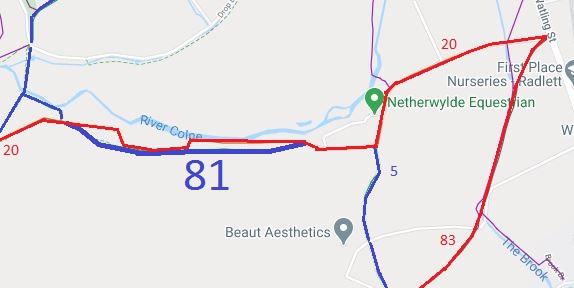

 This route was identified in the 1991 ARROW Survey as one that was ridden but was unrecorded. As a result the landowner was approached, and he was happy to dedicate for the avoidance of doubt enabling the path to be recorded by the quicker method.