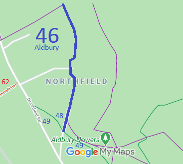
Annotated map reproduced courtesy of Googlemaps.
We need a volunteer to photograph this route for this year's Access and Riding Rights of Way Survey. It's easy - just take photographs (safely) when you use the path. Find out more!
| Paths Greenways Bridleways Tracks | ||
| PG: OBJECTS: PROMOTION: Aldbury 46 and 48 BW - Northfield Road | ||
Annotated map reproduced courtesy of Googlemaps. |
This route runs from Aldbury 49 bridleway, generally northwards to the county boundary and Pitstone 12 bridleway (in Buckinghamshire).
We need a volunteer to photograph this route for this year's Access and Riding Rights of Way Survey. It's easy - just take photographs (safely) when you use the path. Find out more! |
| Legal History 6 Oct 1997: The Ashridge and District Bridleways Association applied to record this route as a bridleway. HCC reference DAC/62. 1 Jul 2011: The Hertfordshire County Council (Aldbury 46 and 48) Public Path Creation Order 2011 (confirmed 27 Apr 2012) created this bridleway. |
Definitive Statement (4 Dec 2015)
Path: [Aldbury] 46. Status: Bridleway/Footpath. Definitive Map sheets: 51 and 52 Commences as a FP south at Aldbury Nowers Wood thence SW across FP 51 then past junction with FP 50 thence W and NW to junction with BR 48 at SP 9487 1324 SW of Turlhanger's Wood. Continues as a BR running N along track to the White House at SP 9491 1348 then following the track NW, N and E around the garden of Northfield Grange to SP 9490 1359 then continuing N to join Aldbury FP 72 and Pitstone BR 12/4 at the Bucks county boundary S of Pitstone Hill at SP 9483 1392. Width: Between 5 and 10.5 metres, as shown shaded grey on the Order Plan of the Hertfordshire County Council (Aldbury 46 and 48) Public Path Creation Order 2011. Limitations: None between SP 9487 1324 and SP 9483 1392. Path: [Aldbury] 48. Status: Bridleway.
Definitive Map sheet: 51 |
© 2022 Patchetts Green Bridleways Trust.
File reference: EC222.
HCC reference: DAC/62.
