Legal History
1839: Sheppey's Lane (most of Abbots Langley 19) was shown on the Abbots Langley tithe map as not subject to an apportionment. Plot 511, roads and wastes.
Draft map: The parish survey recorded this as a bridleway. DM sheet DM3-29.
20 Jun 1953: The route was recorded as a footpath on the original definitive map and statement. DM sheet DM3-29.
9 Dec 2020: Application to record Sheppey's Lane as a restricted byway.
HCC reference: 3R/107.
|
| Application Process |
| Path |
Application |
Certificate |
Direction |
Inv Report |
Order |
Confirmed |
| EC201 |
9 Dec 2020 3R/107 |
16 Jan 2021 |
|
|
|
|
|
Definitive Statement (4 Dec 2015)
Path: [Abbots Langley] 19. Recorded Status: Footpath.
Definitive Map sheet: 75
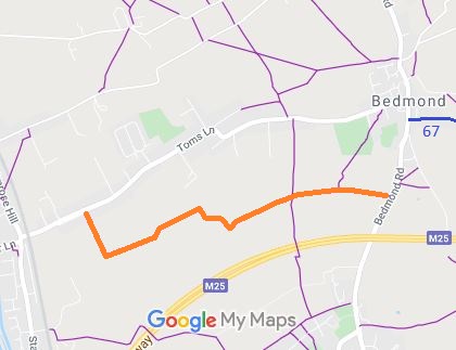
Commences from Toms Lane 230 yards SW of "The Pavings" thence SE and E to Sheppey's
Lane thence SE and generally NE along Lane across FP21 to join Redmond Road opposite
Great Notley.
|
Maintainability
This route is maintainable at the public expense because it was a footpath or bridleway existing before 30 Apr 1959.
|
|
 If you have ridden the route, please download a user evidence form and then follow the instructions and return the form to us. It only takes a few minutes to fill in (the whole form fits on one side of a piece of A4 paper). If you have any other questions, please email us.
